Mapping the Physical World with Netradyne Intelligence

A single stop-sign event tells you something about a driver. Thirty-one events from twenty-two vehicles at the same location tell you something about the world.
That distinction is at the heart of physical AI. By connecting computer vision at the edge with location, time and observations across a fleet, individual detections become collective intelligence. The system does not simply record what happened. It begins to recognize patterns, detect change and build context about the environment around us.
AI has become very good at understanding digital information. The next frontier is the physical world. That requires more than a large language model or a cloud database. Physical AI needs perception. It needs spatial awareness. It needs memory. And it needs a way to recognize when reality has changed.
To be actionable, that intelligence cannot depend entirely on sending the physical world back to a data center to understand it.
Netradyne Intelligence starts at the edge
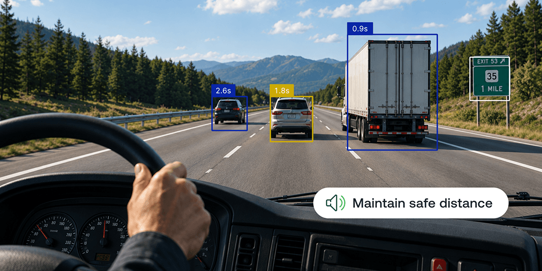
Every Netradyne Driver•i equipped vehicle uses computer vision and onboard AI to interpret the environment around it as it moves through the physical world. It analyzes 100% of driving time and can understand roadway objects, conditions and behaviors where they occur, then contribute those observations to a broader logic layer, Netradyne Intelligence.
We have been building this foundation for years. Now we are taking the next step: connecting those edge observations across location and time to create geospatial intelligence that becomes richer, more current and more useful as the Driver·i network moves through the physical world. This is AI grounded in reality: perception at the edge, collective intelligence across the network, and intelligence that reflects what is actually happening on the road.
From computer vision to physical intelligence
A camera can detect a stop sign. Physical intelligence requires much more. Where is the sign? Which direction of travel does it apply to? How many independent observations support its existence? When was it last seen? Has the environment changed since the last observation? Those are fundamentally spatial questions.
Netradyne Intelligence aggregates and clusters road and environment geospatial observations collected from vehicles traveling through the same locations. For detected roadway elements, we can maintain attributes including location, direction of travel, observation frequency, recency and confidence. That transforms a visual detection into something much more useful: a continuously refreshed representation of the physical world.
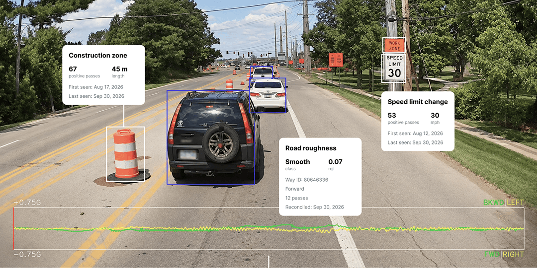
Consider speed-limit data. Traditional mapping data remains important because road rules can exist even when a visible sign does not. But map databases are snapshots. They have update cycles. A vehicle passing a speed-limit sign today gives us an observation from today. That distinction becomes increasingly important when the road changes quickly.
The map can learn from the fleet
The real technical breakthrough is not detecting an individual object. It is creating collective intelligence from many observations over time. We are applying the same architecture to changing roadway conditions such as construction zones. Our systems can identify where construction begins and ends, track when it was first observed and when it was most recently observed, and maintain an understanding of which construction zones appear to remain active.
We are also developing intelligence around road roughness, potholes and other physical characteristics of the roadway. This creates a very different kind of map. A traditional map describes where things are. Geospatial intelligence can describe what is happening there now. Construction appears. Road surfaces deteriorate. Lane markings disappear. Weather changes conditions. Because those observations come from vehicles operating in the real world, each new drive can make that understanding more current. One vehicle perceives. The network learns.
The next layer is understanding risk
Once perception becomes geospatial, another class of intelligence becomes possible.
We can associate safety events with locations. One hard-braking event at an intersection may mean very little. But if dozens of different vehicles repeatedly brake hard at the same location, the location itself becomes a signal.
Our internal risk mapping already allows us to identify locations where multiple vehicles are generating similar safety events. In one example reviewed by our engineering team, a single location had produced 31 violations across 22 unique vehicles.
That changes the analytical question.
Instead of asking only: What did the driver do? We can begin asking: What is it about this place that repeatedly creates risk? That is where physical AI starts moving beyond driver analysis and toward an understanding of the operating environment itself.
Weather shows what this architecture can become
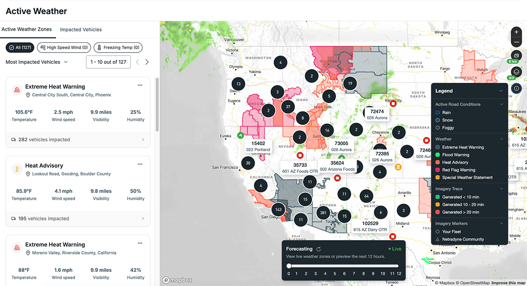
Our Active Weather capabilities connect weather conditions with vehicle location so fleets can understand which assets are being affected, while severe-weather intelligence can reach drivers when those conditions become relevant to them. But external weather data is only one layer.
Physical AI creates the opportunity to understand what vehicles are actually experiencing. There is a meaningful difference between knowing that snow is falling in a region and understanding whether snow or ice is accumulating on the road itself.
The same is true for flooding, degraded lane markings, construction, road debris and other conditions that can change much faster than a conventional map. Over time, vision can help close the gap between forecast conditions and observed road conditions.
From maps to route intelligence
This is where geospatial intelligence becomes particularly powerful. A route is not simply a sequence of roads. It is a constantly changing combination of road geometry, weather, infrastructure, construction, surface quality and historical risk.
Combine those signals and a future system can begin reasoning about the relative risk and operating conditions of the route itself. That could include inputs such as recurring hard-braking locations, active construction, severe weather, roadway conditions, speed-limit changes, road roughness and infrastructure constraints such as low clearances.
Over time, this foundation could support a new class of route-level intelligence. By bringing together current road conditions, environmental context and recurring risk patterns, routing, safety and operational systems could make more informed decisions based on what is actually happening in the physical world.
This is what physical AI looks like
Much of the AI conversation today begins with information that already exists in a database. Physical AI begins somewhere else. It begins with the world.
Vehicles perceive that world through cameras and sensors. Edge intelligence interprets what they see. Geospatial systems organize those observations across location and time. Collective intelligence establishes confidence, detects change and identifies patterns. Applications can then turn that understanding into alerts, risk models, routing intelligence and operational decisions.
That is the foundation we have built.
The opportunity is much larger than a smarter dashcam or a better map. It is a fleet-scale intelligence network that perceives the physical world at the edge, organizes those observations across space and time, and turns them into intelligence that other vehicles, systems and workflows can use.
- Every mile becomes an observation.
- Every observation makes the full context more current.
- Every vehicle can benefit, in real-time, from what the network has already seen.
Want to see Netradyne Intelligence in action? Request a product walkthrough.

Искате да защитите шофьорите и да намалите разходите?
Това не е трик въпрос. Вижте сами с демонстрация.